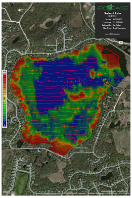
PLM Advances Inland Lake Mapping With BioBase
PLM has recently upgraded our GPS technology to bring our customers a revolutionary new mapping for your lake or pond. This new technology, combined with state of the art High Definition GPS/Depth Finder Units, has the ability to quickly collect precise bathymetry (depths) and aquatic vegetation of any given water body. The data can then be used to create accurate bathymetric, vegetation biovolume or treatment maps in record time. The new mapping will be an excellent management tool and a great affordable avenue for lake associations to update old, inaccurate lake maps. PLM will also be using this software when working with the regulators to bring our customers the best possible lake management options available. We will continue to keep you updated as we learn more about all the software’s capabilities.


